The Landslide Blog is written by Dave Petley, who is widely recognized as a world leader in the study and management of landslides.
One of the most landslide-prone locations on the planet is the catchment known as the Sedongpu gully, which is located on the Tibetan Plateau. Located at [29.8009, 94.92014], this is an area of steep topography that has suffered multiple large, in some cases valley-blocking, landslides in recent years. However, until now there has not been a detailed examination of what is going on at this site.
In a paper just published in the Journal of Rock Mechanics and Geotechnical Engineering, Li et al. (2024) have used satellite data from 1969 to the present to examine the patterns of landslides in the Sedongpu gully catchment. The paper is open access, and is worth a read.
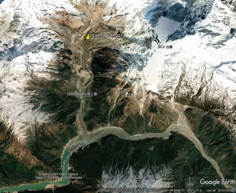
The Google Earth image below shows the area – this image was collected in April 2021:-
Google Earth image of the Sedongpu gully, collected in March 2021.
The catchment in question is in the centre of the image draining towards the south into the Yardung Zangbo river. This image captures the aftermath of one of the large landslide events – note the sediment choking the Yardung Zangbo.
In total, Li et al. (2024) have identified 19 large mass wasting events in this catchment since 1969, consisting of eight ice-rock avalanches, two ice-moraine avalanches and nine glacier debris flows. This is an astonishingly high event rate – the catchment only covers 66.8 km2, and it is only ∼11 km long. But even more extraordinary is the timing as >68% of the events have occurred since 2017.
I have tried to capture the extraordinary change in this catchment in the image compare below. The left image is from 2001, whilst the second is from 2021:-
So two key questions are: first, why is this location so active, and second, why has the event rate become so high in the last seven years?
The answer to the first is probably a combination of a very steep topography, a highly fractured rock mass and the presence of large volumes of sediments from recent glaciations.
But why the recent activity? On 18 November 2017, an Mw=6.4, depth = 10 km earthquake occurred, with the epicentre located just 8 km from the Sedongpu Gully. The high level of recent landsliding has occurred since this event, suggesting that strong seismic shaking destabilised the slopes.
But, in addition, this area is subject to rapid warming as a result of climate change. Li et al. (2024) demonstrate that temperatures rarely exceeded 0°C prior to 2012, but since this time it has become a regular occurrence.
Thus, it is likely that there is extensive permafrost degradation occurring in the catchment, resulting in the progressive destabilisation of the slopes. The 2017 earthquake then initiated the current period of instability.
Since 2017, >700 million cubic metres of debris has been mobilised in the Sedongpu gully catchment. Li et al. (2024) show that a combination of a chronic problem (long term warming) and an acute event (an earthquake that generated intense local shaking) have served to greatly enhance landslide activity. The Sedongpu gully catchment is remote, so the local impact on humans is low. But valley-blocking landslides can project a hazard for hundreds of kilometres downstream. There is increasing evidence that the infrastructure that we are building in high mountain areas, such as hydroelectric dams, is failing to account for these large events. This is a folly.
Reference
Li, W. et al. 2024. More mass wasting activities reported in Sedongpu gully of Tibetan Plateau, China. Journal of Rock Mechanics and Geotechnical Engineering.
Text © 2023. The authors. CC BY-NC-ND 3.0Except where otherwise noted, images are subject to copyright. Any reuse without express permission from the copyright owner is prohibited.
Related