The Landslide Blog is written by Dave Petley, who is widely recognized as a world leader in the study and management of landslides.
On 30 July 2024, heavy rainfall triggered landslides in the Wayanad district of Kerala, India. At the time of writing, the confirmed loss of life has reached 392 people, with a further 150 people reported to be missing. In addition, there were at least 273 injuries.
The event is sufficiently significant that it has its own Wikipedia page, which reports 570 mm of rainfall in the two days leading up to the tragedy. The area affected, including the villages of Punjirimattom, Mundakkai, Chooralmala, Attamala, Meppadi and Kunhome, consists of tea farms built on steep slopes. Many of the people killed were worked in the farms, or were members of their families.
Obtaining optical satellite imagery of the area affected is extremely difficult during the monsoon period, but ISRO has released radar images of the site:-
Satellite imagery of the source zone of the Wayanad landslides in India, from ISRO via the Hindustan Times.
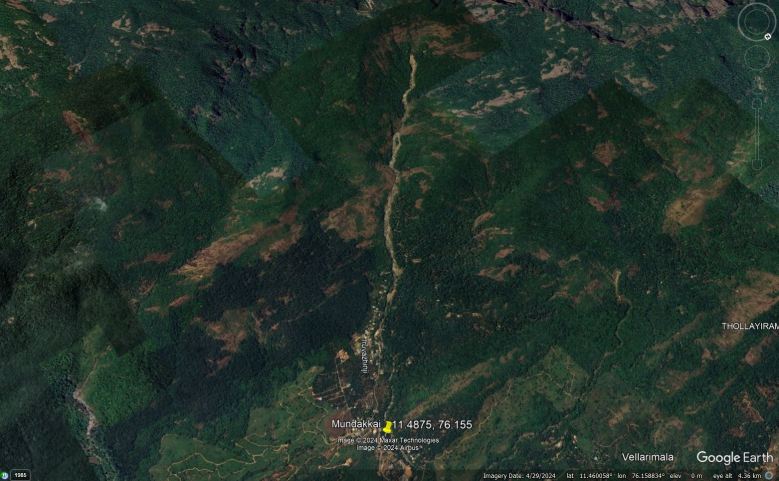
The left (false colour optical) image shows the site prior to the 30 July 2024 event, whilst the image on the right provides radar data that shows the area after the Wayanad landslides. The Google Earth image below shows the site in April of this year:-
Google Earth image of the site of the 30 July 2024 Wayanad landslides in Kerala, India.
The location of the headscarp is [11.46544, 76.13576]. The images before the 30 July 2024 shows the presence of a long runout, channelised flow, which appears to have occurred in 2020. The landslide did not quite reach Mundakkai. As the ISRO imagery shows, the initial failure for the 30 July 2024 event occurred on the same slopes, but on a much larger scale, creating a series of channelised debris flows that ploughed through the villages.
The ISRO analysis suggests that the landslide covers an area of 86,000 m2, with a runout of 8 km.
The Indian Express has posted a video that shows drone footage of the aftermath of the landslides:-
The images are devastating. The scale of the disaster is revealed in this portion of the video:-
Drone image of the aftermath of the 30 July 2024 landslides in Wayanad, India. Still from drone footage posted to Youtube by The Indian Express.
The Wikipedia article reveals a very strange element to the response to this disaster:-
“The Kerala state government issued an order to scientific and technology institutions prohibiting scientists from visiting the site or discussing the landslides or their potential causes. It said that prior approval from the Kerala State Disaster Management Authority would be required before beginning any research in a region affected by a disaster. Hours later, the gag order was revoked unconditionally.“
It is deeply unhelpful to hinder the efforts of the research community to understand the causes of landslides of this type.
Text © 2023. The authors. CC BY-NC-ND 3.0Except where otherwise noted, images are subject to copyright. Any reuse without express permission from the copyright owner is prohibited.
Related