The Landslide Blog is written by Dave Petley, who is widely recognized as a world leader in the study and management of landslides.
On 20 August 2024, a landslide occurred on the banks of the Teesta River near to Baluatar in Sikkim, northern India. This large failure was widely captured on mobile phone videos that have been shared via social media. This is an example:-
There is a different angle of the same landslide here:-
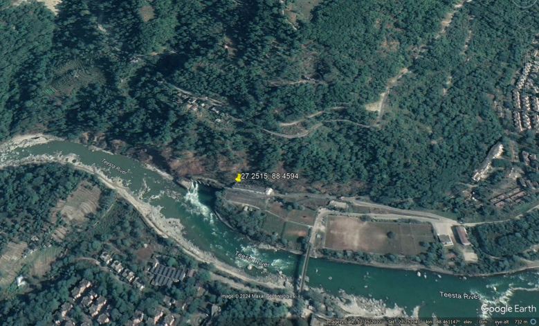
The location of the landslide is [27.2515, 88.4594]. This is a Google Earth image of the site, collected in 2022:-
Google Earth perspective view of the 20 August 2024 landslide at the Teesta V power house in Sikkim.
The marker is located at the end of the power house building, which appears to have been damaged by the landslide. An initial view of the slope above that site, which failed, would suggest to me that this is not the first landslide in this area.
There are multiple interesting aspects of this landslide that bear consideration. The first is the causation – the videos suggest that the landslide occurred in dry conditions. Although the monsoon in India has been very intense this year, my good friend Praful Rao of Save the Hills has pointed out to me that this part of India is in rainfall deficit. This is intriguing.
So, what lies behind it? I would ask two questions, assuming that the failure will be investigated in more detail. The first is whether the slope was cut to create a bench for the power infrastructure? This is a Google Earth image of the site in 2011, the earliest in the archive:-
Google Earth perspective view from 2011 of the site of the 20 August 2024 landslide at the Teesta V power house in Sikkim.
Whilst I cannot say definitively, there ae indications in this image that the slope may have been altered. If so, failure less that two decades later would ask serious questions about the engineering at this site. Of course, there is also underground infrastructure here, so there are other ways in which the integrity of the slope might have been damaged.
The second question related to the fact that this area was affected by the massive 4 October 2023 glacial lake outburst flood (GLOF) from South Lhonak, which caused immense damage along the Teesta. Praful and the Save the Hills team have done some magnificent work on understanding the impact of this event – I’d highlight a series of posts on the impacts along the river, which even includes a post about the area affected by the landslide yesterday. In June this year, Save the Hills highlighted that urgent action was needed along the Teesta to prepare for the rainy season:-
“We need an expert team to visit these areas and advise us the course of action to be taken in the limited time we have before the next monsoons.
“We should focus on building the resilience of communities in the flood affected areas while continuing with the recovery and reconstruction process, since many of our populated areas in the Teesta Valley in Sikkim and W Bengal will again be affected during the Monsoons 2024.
“Time is of essence“
In July they highlighted the ongoing problems, most particularly that the aggradation of the river bed (increase in level due to the deposition of sediment) was causing massive issues.
The Save the Hills post about this specific site shows the massive damage that was inflicted in this area by the GLOF. So the second key question is whether the slope was affected by the flood, either through direct erosion of the toe or by changes to toe buttressing, for example? At this stage there is insufficient information to know.
But of course, this returns to a familiar issue in the Himalayas, which is that large energy infrastructure projects, costing hundreds of millions of US dollars, are being repeatedly destroyed by landslides and debris flows. I wrote about this problem in 2021, but highlighted a paper that I wrote about it (and a presentation that is available online) almost a decade earlier (Petley 2013 – available online).
It is clear that the planning of these projects is repeatedly failing consider adequately both the complex geological settings and the occurrence of events that can cause complete loss of these pieces of infrastructure. I am amazed that the funders and insurers of these projects are not seeking urgent answers as to how this can occur repeatedly.
This situation is only going to get worse. The rate of warming caused by anthropogenic climate change in these high elevations is rapid, and we have strong evidence from around the world that this is increasing the rate at which large rock slope failures are occurring. Furthermore, data from just this year shows that higher temperatures is causing more intense rainfall and thus more landslides.
This is an urgent issue – many more hydroelectric projects are planned in the Himalayas, but it appears that no actions is being taken. And even when a large event has occurred, and organisations like Save the Hills are highlighting the short term risks, nothing is being done.
We cannot continue like this.
Reference
Petley, D. 2013. Global losses from landslides associated with dams and reservoirs. In: Genevois, R. and Prestininzi, A. (eds) International Conference on Vajont – 1963-2013. Thoughts and analyses after 50 years since the catastrophic landslide, pp 63-72.
Text © 2023. The authors. CC BY-NC-ND 3.0Except where otherwise noted, images are subject to copyright. Any reuse without express permission from the copyright owner is prohibited.
Related