The boomer was broken.
Three days and roughly 200 kilometers into a scientific cruise through New Zealand’s fjords, one of the critical instruments aboard the R/V Polaris II was out of commission.
Scientists from the University of Otago had rolled through South Pacific swells on their way to Fiordland, on Te Waipounamu/the South Island’s southern tip, for a 3-week expedition to measure how much carbon is stored in the depths of New Zealand’s remote and spectacular fjords.
To do that, they had to map the undulations of the seafloor of each fjord and the thickness of the organic material buried there. To do that, they needed an electroacoustic subbottom profiler—colloquially called a boomer—which sends low-frequency pulses of sound down through the water. The boomer is towed behind the ship as part of a sonar system that alongside an array of listening hydrophones and an onboard receiver, records and images the undersea landscape.
But when researchers hooked everything up and tried to take measurements, nothing happened. “It wasn’t booming. We had no boom,” said expedition leader Chris Moy, an Earth scientist originally from New York. The power source was kaput.
The team was several days’ travel from the nearest hardware store. Not that it mattered; this was a pretty specialized piece of equipment. They’d already had one false start—having to return to the seaport of Bluff, a 12-hour journey, when a bearing on the ship’s rudder shaft had broken a few days prior. They couldn’t afford another setback.
Luckily, Moy had satellite internet on the ship, and he quickly found a colleague of a colleague at New Zealand’s National Institute of Water and Atmospheric Research in Wellington who had a boomer power source he was willing to lend.
The Wellington researcher put the 23-kilogram (50-pound) waterproof case on the 1.5-hour flight to Dunedin, where an Otago technician picked it up and drove it 3 hours to Te Anau, the small town on the edge of Fiordland National Park. At that point, Moy called in a favor from Southern Lakes Helicopters. The company happened to be sending a chopper to Tamatea/Dusky Sound (where the Polaris II was anchored) to pick up some hikers and was happy to haul the extra cargo.
Much of the Fiordland coastline consists of mossy cliffs that drop straight into the sea. But at the head of Dusky Sound at Supper Cove—presumably named after an 18th century dinner party hosted by British explorer Captain James Cook, who visited in 1770 and 1773—there’s a narrow strip of grassy, rocky beach above the high-tide line where it’s possible to land a helicopter. A couple of the Polaris II crew jumped into an inflatable Zodiac and whizzed ashore to meet the chopper and collect the vital piece of equipment. Less than an hour later, the boomer was booming—and the science was underway.
Into the Wild
Doing research in Fiordland frequently requires this type of on-the-fly collaboration and ingenuity, a brand of resourcefulness referred to in New Zealand as “number 8 wire mentality”: the ability to solve any problem with a length of 4-millimeter-diameter (0.16-inch) metal wire and a bit of elbow grease.
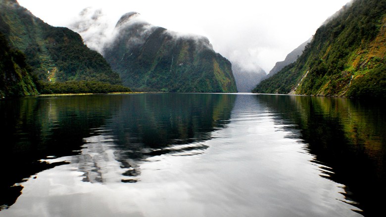
All of the elements that make Fiordland a highly productive carbon sink—the lush, thick rain forest; the regular earthquakes and landslides; the lack of human settlements, shops, or roads; the steep-sided mountains; and the preposterous quantities of rainfall—also make it an extremely challenging place to research.
“You’re really at the mercy of the ocean and the weather in here.”
“You’re really at the mercy of the ocean and the weather in here,” said Rebecca McLeod, a marine ecologist who has a long connection to the region and serves as the chair of the Fiordland Marine Guardians.
Because of the region’s relative isolation and inaccessibility, scientists have only recently begun to comprehensively study the coastline: Fiordland’s signature black corals were first mapped in 1985.
In addition to its dramatic coast, Fiordland’s mist-shrouded interior has also been the site of improbable discoveries. In 1948, Invercargill doctor Geoffrey Orbell found a population of takahē, chunky endemic swamphens presumed extinct for 50 years, in the Murchison Mountains near Lake Te Anau. In 1975, conservationists found a single kākāpō—another flightless bird endemic to New Zealand—living in a steep-walled valley near Milford Sound. Dubbed Richard Henry, he was the last surviving individual from Fiordland and became crucial in improving the genetic diversity of the critically endangered species.
To meet the team on Polaris II, my photographer colleague and I drove west from Dunedin. As we approached the wall of mountains that mark the entrance to Fiordland National Park, strange clouds piled up in the sky. The weather forecast on my phone flashed orange with a heavy-rain warning for the day. “Expect 300 to 400 mm of rain, with the largest amounts about the fiords,” it read. “Streams and rivers are likely to rise rapidly and damage to trails and roads is possible.”
It started raining that evening when we met McLeod in Te Anau, and it didn’t stop for 36 hours. We caught the morning ferry across Lake Manapouri and rode the bus over the waterfall-strewn Wilmot Pass down to Deep Cove, the most inland and accessible finger of Doubtful Sound. There, we jumped aboard the Polaris II.
R/V Polaris II is a 21-meter refitted former fishing boat that has proved invaluable to oceanographers at the University of Otago in New Zealand. Credit: Alan Dove/University of Otago, CC BY 4.0
“It’s My Happy Place”
The expedition had already been underway for 2 weeks, with one and a half to go.
The first thing I saw aboard the ship was the wet lab: stainless-steel bench tops crowded with scissors, aluminum foil, glass bottles, paint scrapers, surgical gloves, bungee cords, Ziploc bags, and a drill.
Luke Whibley, a master’s student, was working with little bottles of seawater collected for later analysis, adding mercuric chloride to kill any microbes that might alter the chemical composition of the samples during the voyage. He said he loves it in Fiordland: “It’s my happy place.”
“This is the real Fiordland.”
“Has it been this damp the whole time?” I asked.
“No, it’s really turned it on for you guys,” Whibley replied. “The first 10 days or so it was pure sun; we were out there swimming off the back of the boat.” Such balmy weather seemed a bit unnatural, though, and the team wondered when the rain would start.
“This is the real Fiordland,” Whibley said, gesturing at the waterfalls upon waterfalls laddering up the cliffs into the clouds and the steady drizzle pouring off the deck roof. It rains 6–10 meters (20–33 feet) per year there—possibly more in some places. (Most of these wild valleys have no rain gauges to keep track.)
Water cascades down the mountainsides and through the rivers that flow into the fjords, bringing organic material with it. Looking out the wet lab’s open door, I could see leaves and even a few big logs speckling the surface of the water—visual reminders of just how much carbon was moving from forest to sea.
Much of that organic matter is buried in the fjords’ deeps, trapped in the soft black mud the Otago team was hauling to the surface with a Moon lander–esque multicorer. The instrument takes four identical core samples of the top layer of sediment and the seawater above it. On deck, a group of students and technical staff prepared the collection for later analysis.
“There are all kinds of scientists doing all kinds of amazing science here, and along comes an economist with slightly annoying questions—because we want to see the big picture.”
Jorgee Robb, a master’s student in waterproof overalls and braids, scraped a layer of chocolaty sediment from the core with a soup spoon and shimmied it into a plastic bag. Back at the lab, it would be analyzed for grain size, carbon isotopes, trace metals, biomarkers, and fossil and radiocarbon content. Together, those data will reveal which fjords store carbon fastest, where the organic material originated, and how those origins have changed over time.
The Otago team is multidisciplinary: physicists and Earth scientists and marine ecologists and oceanographers. There is even a mother-son team of economists from New Zealand’s Lincoln University. The pair is developing a comprehensive computer model to estimate the amount of carbon moving into and out of the entire fjord system and to assess the value of the resource under different carbon pricing scenarios.
“There are all kinds of scientists doing all kinds of amazing science here, and along comes an economist with slightly annoying questions—because we want to see the big picture,” said Caroline Saunders as we were getting monstered by sand flies up on deck at dusk. She’d spent the day nutting out the relationships and variables that might affect carbon sequestration in the fjords, as well as getting a visceral, visual sense of the environment and the scientists’ work.
We Need a Bigger Boat
“Our slogan for the trip has been ‘We need a bigger boat.’”
Bad weather, bugs, and broken boomers and bearings were not the only challenges on the expedition. “Our slogan for the trip has been ‘We need a bigger boat,’” Moy said. The Polaris II is about 19 meters (63 feet) long—perfect for squeezing into narrow, shallow parts of a fjord but also very cramped. “We’re trying to do as many things as possible in a very small place,” he explained.
In the wet lab, a washing machine shared space with laptops, gumboots, and titration instruments. Below deck, the accommodations were spartan—bunks crammed into the tiniest of rooms.
For introverts like Robb, it’s not easy being surrounded by people 24/7. She looked for moments—like at dinner time, when everyone else was gathered upstairs—to hide away for a minute. “So you can have your own little bit of time by yourself,” she said.
During the cruise, the scientists lowered the multicorer 12 times in four different fjords to sample the mud-seawater interface. They took longer, deeper sediment cores with a different instrument to identify changes in carbon burial over time. They collected seawater from different parts of the water column to analyze temperature and salinity, measured seafloor sediment depth with the boomer, and assessed tidal currents.
Responsibility for keeping the scientists physically safe while they worked fell to the crew. “There’s negotiation, absolutely—[the scientists’] plans are often not realistic, what they want to achieve in a day,” said skipper Adelle Heineman, a former marine scientist herself.
While the researchers focused on science, the crew was constantly aware of the weather and the tides, figuring out which anchorages would be safe and when it was time to move on. The internet connection was crucial. “That’s the beauty of having satellite internet because we can monitor weather patterns and things much more easily,” Heineman said. (I also watched Moy log on to place a huge online supermarket order of fresh produce for the final week of the expedition.)
The downside of connectivity—this is only the second field season the internet’s been in use—is a slightly less collegial atmosphere in the evenings, Heineman and Moy pointed out. People are on their phones more and get roped into drama at home. “It’s made us too connected, you know?” Heineman said. “Part of the beauty of coming in here was being remote and just walking away from social media and life in the city.”
“When the weather’s atrocious, and then we’re like, ‘Oh, we just need our 3,000th sample’…they go above and beyond.”
This expedition had three skippers who rotated in and out—the result of the university’s new fatigue policy requiring that crew work no more than 14 consecutive days. The hours are certainly long, and “we ask a lot of [the crew],” McLeod said. “They really have to believe in the science. When the weather’s atrocious, and then we’re like, ‘Oh, we just need our 3000th sample’…they go above and beyond.”
It’s all worth it to get to spend time in this special and untrammeled place, Heineman said. “It’s just magical—just untouched beauty.” Well—not entirely untouched. Heineman said she likes to remind students and scientists that there’s a lot of human history here too.
Māori have paddled and fished these inlets and hunted these forests for generations and still do today. Over the past couple of centuries, Pākehā (New Zealand Europeans) have also tried to make a go of it in the region, but permanent settlements and land-based industries have, for the most part, failed (though the crayfishing grounds are legendary).
Now, much of this unique landscape and the carbon it holds safe are protected as part of New Zealand’s largest national park. At around 12,600 square kilometers (5,000 square miles), Fiordland National Park is also part of a UNESCO World Heritage area and sits alongside 10 marine reserves.
“People have tried to tame this country; they’ve tried to set up all sorts of businesses, sawmills and brickworks and things, and nobody’s really been successful,” Heineman said. “Like the forest has kind of taken back over. For the most part, you don’t see any human civilization.”
There’s beauty in the wildness, Heineman added. The terrifying blackness of a weather front building out at sea—“just the Tasman sending its wrath”—and the wind blowing so hard the myriad waterfalls don’t even hit the fjord. Even with our helicopters and our satellite internet and our instruments, Fiordland still puts us in our place.
“I guess that’s what I love about it,” Heineman said, “that even when we have tried, we haven’t tamed it.”
—Kate Evans, Science Writer
Citation: Evans, K. (2024), Exploring New Zealand’s remote fjords, Eos, 105, https://doi.org/10.1029/2024EO240364. Published on 12 August 2024.
Text © 2024. The authors. CC BY-NC-ND 3.0Except where otherwise noted, images are subject to copyright. Any reuse without express permission from the copyright owner is prohibited.
Related